How will Hurricane Erin impact Virginians?
 VENN
VENN
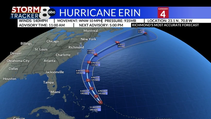
RICHMOND, Va. (WRIC) -- As Hurricane Erin approaches the Virginia coastline, the StormTracker8 team has details on what Virginians can expect to see from the storm.
With winds of 140 mph, this major Category 4 hurricane is forecasted to curve north and eventually northeast, traveling at 10 mph.

Hurricane Erin impacts: courtesy of National Weather Service and National Hurricane Center

Hurricane Erin impacts: courtesy of Stormtracker8
The storm will impact coastal Virginia areas the most as lifts and will result in:
- Large waves
- Coastal flooding
- Dangerous surf zone conditions along Mid-Atlantic coast for much of this week
- Areas of beach erosion likely
Coastal Impacts
According to the National Weather Service, the biggest impact will be rough surf and the potential for deadly rip currents. Areas in Virginia Beach could also see 10-foot waves or higher.
Coastal flooding is possible with vulnerable areas potentially seeing rainfall of up to 2 feet above ground level beginning as early as Tuesday near the beginning of the high tide cycle, according to the National Weather Service.

Hurricane Erin impacts: courtesy of National Weather Service and National Hurricane Center
The immediate coast could also see wind gusts at or surpassing tropical storm force winds at 39 mph or greater, Wednesday into Thursday.
Central Virginia
The central Virginia is not forecasted to receive strong winds. The forecast for this week breezy winds mid-week with gusts on Thursday reaching 20-30 mph.


