StormTracker8: Scattered showers and a possible storm Sunday
 VENN
VENN
Richmond, Va (WRIC) -- After a spectacular Saturday across all Central Virginia, we will see beneficial rain showers on the way for the region on our Sunday. Details below.
Tonight’s forecast for this Saturday night into Sunday morning, calls for increasing clouds leading to mostly cloudy skies, warm temperatures overnight only dropping down to 60 to 65 degrees and isolated showers possible especially after Midnight Saturday night.

Don’t forget to Spring Forward All of your clocks 1 hour ahead, as Daylight Saving Time starts, officially at 2:00 a.m. Sunday morning.

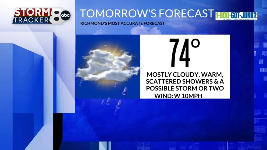
Tomorrow’s forecast for our Sunday calls for mostly cloudy skies, warm temperatures rising to 70 to 75 degrees and scattered showers and a thunderstorm or two possible, as our latest weather system pushes through the region.

Monday to kick off the new work and school week calls for mostly sunny skies, and warm temperatures rising to 75 to 80 degrees.
Tuesday’s forecast calls for partly sunny skies, and warm temperatures rising into the lower 80s. The record high temperature for Tuesday, which is March 10th, was 81 set back in 2006, and right now the forecast high for this Tuesday is 82.
Wednesday’s forecast calls for mostly cloudy skies, and very warm temperatures rising into the middle 80s. The record high temperature for Wednesday, which is March 11th, was 82 set back in 1990, and right now the forecast high for this Wednesday is 85.

Next Wednesday night into Thursday morning brings us a round of likely showers and thunderstorms from west to east, as a stronger cold front will be pushing through the region during this timeframe. Highs on Thursday will likely occur in the morning hours, then we will see dropping temperatures throughout the day.
Next Friday will be cooler, under partly sunny skies and highs 55 to 60 degrees.
Finally, next weekend, looks pretty decent right now with highs in the 60s both days and dry conditions until next Sunday night.


