StormTracker8: Snow coming to an end; icy roads for Tuesday’s commute
 VENN
VENN
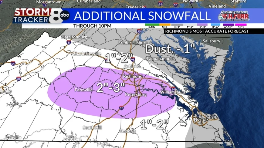
RICHMOND, Va. (WRIC) – Snow will gradually taper off this evening and then we will have cloudy skies tonight with our overnight lows falling back into the upper teens to near 20. Additional accumulations through 10pm will be 2" to 3" for Metro Richmond and Tri Cities with about 1"-2" elsewhere. The next concern is the morning commute where our snow covered roads will freeze and make for an icy/snowy commute, Tuesday morning.

Clouds early Tuesday morning will give way to partly sunny skies and it will be a chilly day with highs only around 35 so we will see minimal melting at best.

Tuesday night we will get back into the lower to middle 20 so things will freeze once again which means icy spots are a good bet for Wednesday mornings commute.
Another weak weather system will approach the region on Wednesday and that will bring us more in the way of clouds and the risk of a few passing showers during the afternoon. It will remain cool for this time of year with highs near 45.
Partly sunny skies will return for Thursday with highs again around 45.
Friday will feature more clouds as another week weather system comes our way and this could bring us also the chance of a quick passing shower during the afternoon. Our high temperatures will only climb into the lower 40s.

Saturday will feature a mixture of sun and clouds with highs near 45.
Another system will approach us for Sunday bringing us more clouds and the risk of a few passing showers. It will remain chilly for this time of year with highs only near 40.
Looking ahead to the early part of next week we should see partly sunny skies for Monday and Tuesday with highs in the upper 30s to near 40.


