StormTracker8: Comfortably cool tonight; more clouds/cooler day on Sunday
 VENN
VENN
Richmond, Va (WRIC) -- It’s been a spectacular Saturday across all Central Virginia, so I hope you got outside and enjoyed it today! We are watching Monday into Tuesday of next work week closely, more details below.
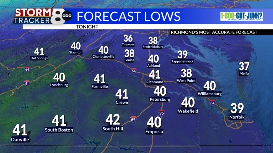
Tonight’s forecast calls for clear to mostly clear skies and comfortably cool temperatures, getting down close to 40 degrees.

Tomorrow’s forecast on our Sunday calls for increasing clouds, leading to mostly cloudy skies and cooler temperatures, rising to 55 to 60 degrees with a possible shower during the day as well.


Tomorrow night into Monday morning, will be much colder once again, on the back end of a weather system sliding through the Mid Atlantic Region on our Sunday. Lows tomorrow night will be down near 30 degrees.
Monday’s forecast to kick off the new work and school week, will be a chilly day across Central Virginia, under mostly cloudy skies, highs around 40 degrees, and a mixture of rain and wet snow on Monday afternoon and Monday evening.

Next Monday night into next Tuesday morning, we will continue to see that mixture of rain and wet snow across the viewing area, and lows down near 30 degrees.
Tuesday’s forecast calls for mostly cloudy skies, with a morning wintry mix, then drying out in the afternoon, with highs 45 to 50 degrees.
It’s important to note that on Monday afternoon through Tuesday morning during the rain and wet snow mixture, that it’ll be mild leading up to the event, the ground will be mild, not expecting major impacts or accumulations.
Next Wednesday through next Sunday, will all be well above average in the overnights and in the afternoons, with at least an isolated chance for rain showers each day.


