StormTracker8: Record warmth possible Tuesday & Wednesday
 VENN
VENN
Richmond, Va. (WRIC) -- Mainly clear skies to be with us for this evening and tonight lows will fall back into the lower 50s.
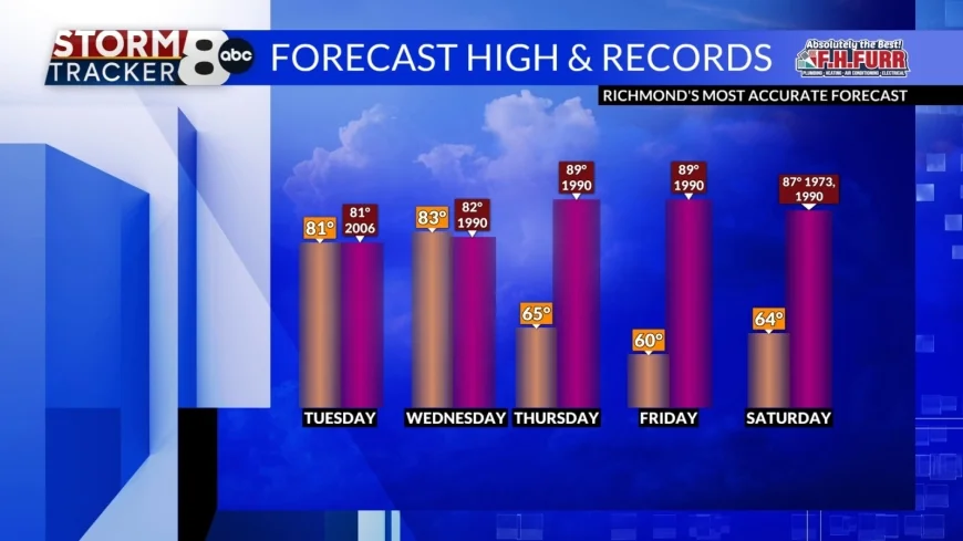
We will see mostly sunny skies for Tuesday and there is the potential to tie the record high of 81 which was set in 2006.

Wednesday will be another warm day with partly sunny skies and a chance to tie or break the record high as we climb into the lower 80s and the record is 82 set in 1990.

A weather system will approach the region on very late Wednesday night into early Thursday morning and kick off around the showers and even some thunderstorms. Our overnight lows will fall into the upper 50s.
We will have some showers and storms early Thursday but then the sunshine should break out later in the afternoon. It will turn windy during the afternoon, and it will be a cooler day with highs 60 to 65.
Friday will feature mostly sunny skies, and it will be a seasonable day with highs around 60.

Mostly sunny skies will be with us for Saturday with highs near 65.
Partly sunny skies will be across the region on Sunday with highs in the lower 70s.
Another weather system will approach the region on Monday giving us the risk of some showers in the morning with some sunshine in the afternoon. Our high temperatures will top out in the middle 60s.


