StormTracker8: Severe Thunderstorm Watch until midnight
 VENN
VENN
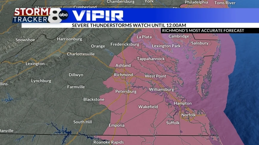
Richmond, Va (WRIC) -- A Severe Thunderstorm Watch has been issued until midnight tonight for all areas along and east of I-95. This is for the front that is moving through Central Virginia creating gusty/damaging winds.

That cold front will move through central Virginia tonight bringing a round of showers and gusty winds. Some of the winds could gust up 40 and 50 mph as the front moves through. Behind that front our clouds will quickly clear and it will be cold as overnight lows will drop back into the lower 30s.

Partly sunny skies will move back in for St Patrick's Day with highs in the middle of 40s.

Wednesday will feature partly sunny skies, and it will be chilly with highs in the upper 40s.
Partly sunny skies will remain with us for Thursday, but it will be a little bit more seasonable with highs in the upper 50s.

Spring begins Friday as it officially kicks off at 10:46 in the morning and we should see a nice spring day with highs in the middle 60s under partly sunny skies.

Looking ahead to the weekend we will see partly sunny skies for both Saturday and Sunday with highs in the upper 60s to near 70 however there could be a quick passing shower Saturday night into Sunday.
By the early part of next week another weather system push into the region bringing us a chance of showers on Monday with highs in the upper 50s and by Tuesday we should see partly sunny skies with highs in the middle 50s.


