StormTracker8: VIPIR Alert for Icy Conditions
 VENN
VENN
Richmond, Va. (WRIC) -- The winter storm is over, but the effects will linger with central Virginia all week. Thankfully, the freezing rain we were anticipating did not materialize yesterday, and ice accumulation did not lead to widespread power outages. The warm air aloft was not thick enough for our precipitation to switch from sleet to freezing rain, so we had a lot more sleet accumulation and not as much ice accumulation. Our snowfall totals fell on the low end of our predictions.
Today, temperatures will stay at or just below freezing. This means our snow and ice will not magically melt and disappear today…. in fact, we are expecting extremely cold conditions for the rest of the week, leading to long lasting impacts to roadways. Today, a VIPIR Alert is in place for the extremely dangerous roads. They are not only covered in snow, but also ice. Please stay home unless you absolutely must go somewhere. VDOT needs to treat the roads safely.

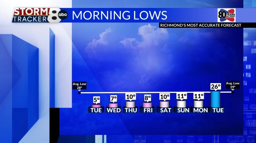
Tomorrow morning will be frigid. Lows will be the coldest we have seen in 6 years, in the low single digits. Wind Chill will fall to the negatives. This is extremely cold and extremely dangerous. If you must be outdoors tomorrow, do not let any skin remain exposed. Wednesday will be very cold as well, with lows in the single digits.

Due to temperatures remaining below freezing for the foreseeable future, pipes are in jeopardy of bursting. Leave faucets dripping and open cabinets to prevent damage, not just tonight, but all week.

We are monitoring a coastal low pressure system at the end of this week that could bring another round of winter weather. Right now, models are trending towards the possibility of snow sometimes Thursday night through Saturday. These models are not agreeing as well as the system we just saw yesterday 6-8 days in advance, so there is no need to panic right now.


