StormTracker8: Windy and seasonable Friday; watching Monday closely
 VENN
VENN
RICHMOND, Va. (WRIC) -- After a Wild weather day on Thursday across the 8 News Viewing area, from showers, thunderstorms, wet snow, dropping temperatures and windy conditions, we are in for a calmer Friday to end out this current work week. We are watching Monday already very closely. Details below.
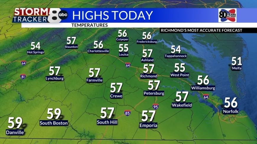
Today’s forecast for this Friday calls for partly sunny skies, breezy to windy conditions from time to time and seasonable afternoon temperatures, rising to 55 to 60 degrees.


Tonight’s forecast calls for partly cloudy skies overnight, and not as cold temperatures, getting down to 40 to 45 degrees.

Tomorrow’s forecast for Saturday calls for partly sunny skies, not as windy conditions and milder afternoon temperatures, rising to 60 to 65 degrees. Saturday is the pick day this weekend for outdoor plans!
Sunday we will start to see some changes ahead of another powerful weather system slated to sweep through the region on Monday of next work week. We will see mostly cloudy skies, highs 65 to 70 degrees and night showers developing by Sunday night.

Monday we will be watching very closely for possible strong to severe storms, as another powerful weather system will be sweeping through the region, under mostly cloudy skies, mild temperatures, rising to 70 to 75 degrees, and likely showers and thunderstorms. We have made Monday a VIPIR Alert Day due to that possibility for strong to severe storms.

Tuesday is St. Patrick’s Day, and it will be a chilly day, under partly sunny skies, and highs around 45 degrees.
Wednesday will be another chilly day, under partly sunny skies, and highs around 45 degrees.
Finally, next Thursday and next Friday both look beautiful under partly sunny skies and afternoon temperatures rising into the 60s. Remember next Friday, March 20th is the Vernal Equinox, or the first official day of Spring, so that’s something to look forward to!


