StormTracker 8: A wet finish the the weekend
 VENN
VENN
RICHMOND, Va. (WRIC) - It was a beautiful start to the weekend and it will be a wet finish with showers and storms around today. The unsettled weather continues the next few days.
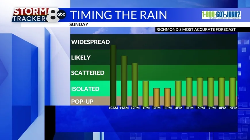
Widespread rain continues for the morning hours before slowly tapering off as we head towards lunch. A few rumbles of thunder are also possible with our biggest threat being localized flooding in poor drainage areas. Damaging winds and small isolated hail are also possible.


The lunch hour and early afternoon looks to be mainly dry with a few breaks of sun however another round of showers and storms moves in by mid afternoon. These will be scattered across the area and the risk stays with us through about 10 pm. It will be a cooler day with highs in the middle to upper 70s.
Any showers and storms end overnight and lows drop into the lower 60s.

Unsettled weather continues for Monday and Tuesday with the risk of showers and a few storms in the forecast. The biggest threat each day looks to be in the afternoon and evening hours with high temperatures near 80°. When all is said and done we should see a widespread 0.75"-1.5" by Tuesday evening with locally higher amounts possible.

Our next fully dry day looks to be Wednesday with partly sunny skies and high temperatures near 80°. Showers move back into the area for Thursday with highs in the upper 70s.

Right now it looks like we will be dry for Friday and Saturday with cooler temperatures near the middle 70s.


