StormTracker8: VIPIR Alert for Sunday; Rain to snow with accumulations
 VENN
VENN
Richmond, Va. (WRIC) -- Mainly clear skies will be with us early this evening, however clouds will increase by early Saturday morning. It will be a comfortably cool night with lows in the middle 40s.

Saturday will feature cloudy skies with the risk of a couple of spotty showers from time to time and it will be a seasonably mild day with highs in the upper 50s.

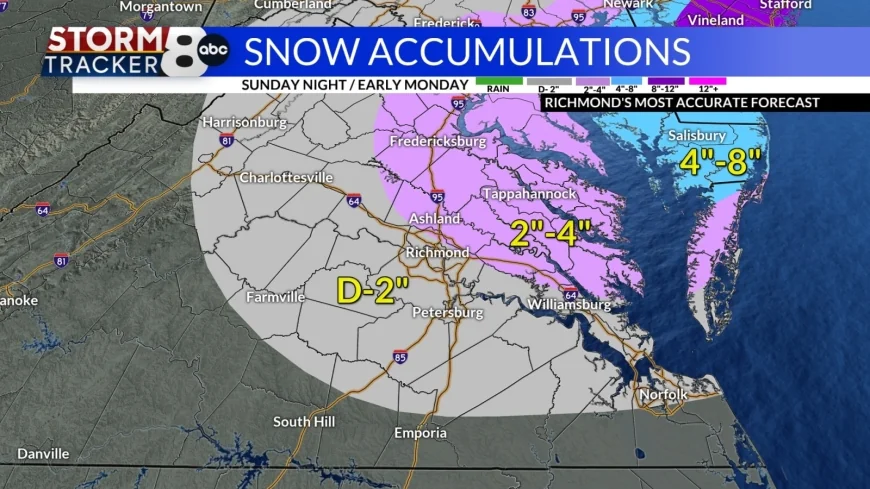
While confidence is growing in the forecast for Sunday into early Monday morning there are still some differences in the weather models that could have an impact on what we receive for snowfall accumulations. The location of the development of the low off the coast of Virginia and the rapid strengthening will dictate the amount of moisture for us and how quickly we start to see that transition from rain to snow, and then how long that snow will last.
Here are the details:

Rain will develop between 5am and 7am and quickly become steady and locally heavy for the morning through afternoon. Temperatures early in the morning will be in the lower 40s and begin to fall during the afternoon into the 30s. Many areas will pick up between a 1/2" to 1" of rain or more, before the transition begins. In other words, it will be a washout!
Between 4pm and 6pm, from northeast to southwest, we will start to see that transition from rain to a mix of rain and snow and then to all snow. As we make that transition the snowflakes will be huge, large half dollar size and then will fill the air. It will look very pretty! That snow will continue for the rest of Sunday night and begin to taper off between 2am and 4am. So, we are looking at a good 8 hours to 10 hours of snow. This will be a wet snow falling on very wet ground, which will initially inhibit snow from accumulating, because the initial couple of hours of snow will have to cool the ground. Most of the roads will be okay, especially across metro Richmond, however on area of concern for road issues will be in the Middle Peninsula and Northern Neck where roads will become slushy and snow covered by early Monday morning.
As far as accumulations:

Henrico, Chesterfield, City of Richmond, Tri-Cities, Dinwiddie, Powhatan, Goochland, Louisa, and all areas in the grey color will see a dusting to 2". If you are closer to the pink band, you will see the upper end of the range, the farther south & west you are, you will see the lower end of the range.
For Hanover, New Kent, King William, King & Queen, Middlesex, Caroline, Spotsylvania, Essex, Richmond, Lancaster, Northumberland and the rest of the Middle Peninsula and Norther Neck you will receive between 2"-4" of snow. The farther north & east you are the more snow you will receive.
Notice the accumulations in the Delmarva, 4"-8", and then more into New Jersey and Long Island, 8"-12" and possibly more.
This is a very tricky forecast, because if that low off the coast of Virginia is closer and depends faster, pulling down the colder air quicker, it is very conceivable that the higher amounts over the Delmarva could slide across the Chesapeake Bay and sit over the Northern Neck. That difference would shift all the bands and amounts to the southwest.
Due to these differences in the development of the storm, this remains a low confidence forecast at this time.
As that storm departs on Monday morning, we should see clouds give way to partly sunny skies, but it will remain chilly with highs in the lower 40s.
Partly sunny skies will be with us for Tuesday with highs in the middle 40s.
Wednesday will finally be back to normal with highs in the lower 50s under partly sunny skies.
Another weather system will push into Central Virginia on Thursday, and that will bring us the chance of some rain with highs in the upper 50s.
Looking ahead to the end of next week we will see mostly sunny skies for Friday and Saturday with highs remaining in the lower to middle 50s.


