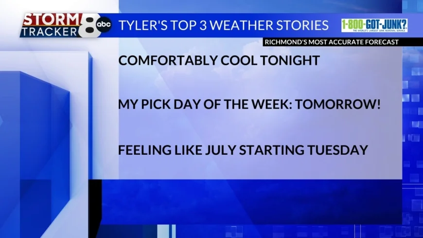
StormTracker8: Comfortably cool tonight; beautiful day on Sunday
 VENN
VENN
Richmond, Va (WRIC) -- Central Virginia is in for well above average conditions next work week, for the week of April 13th, making it feel much more like July. Details below.
Tonight’s forecast for this Saturday night calls for mostly clear skies early then partly cloudy skies by Sunday morning and comfortably cool conditions, with overnight lows dipping down to around 50 degrees.
Tomorrow’s forecast for our Sunday calls for my pick day of the next 8 days, as we will see partly sunny skies tomorrow, breezy conditions from time to time, and beautiful afternoon temperatures, rising to 75 to 80 degrees.
On Monday morning we will see a warm front lift through the Mid Atlantic Region, and that will lead to warming temperatures for the next several days. On Monday afternoon we will see partly sunny skies, breezy conditions from time to time, and very warm afternoon temperatures, rising into the middle 80s.
Tuesday will begin a Hot stretch of weather over Central Virginia, as a strong ridge of high pressure will be developing and bring well above average conditions. In fact, it’ll feel much more like July standards instead of Mid-April standards from next Tuesday through next Sunday over the 8 News Viewing area. Tuesday afternoon will bring us partly sunny skies, and hot, with afternoon temperatures rising to around 90 degrees. The record high for April 14th is 90 degrees, which was set back in 1977.
Wednesday will be another hot April day, as the strong ridging pattern persists, as Wednesday afternoon we will see partly sunny skies, and hot, with afternoon temperatures rising to around 92 degrees. The record high for April 15th is 92 degrees, which was set back in 1941.
Thursday appears to be the hottest day of the next 8 days overall, as we will see partly sunny skies, and high temperatures rising to around 93 degrees, as the record high for April 16th is 93 degrees, which was set back in 1976.
Friday will be another hot day, under partly sunny skies, and afternoon temperatures rising to around 90 degrees.
Next Saturday will be yet another hot day, under mostly cloudy skies, and afternoon temperatures rising to around 90 degrees.
Finally, next Sunday will be yet another hot day, under mostly cloudy skies, and afternoon temperatures rising to around 92 degrees.
Next Sunday night, multiple computer weather models are suggesting isolated showers and thunderstorms possible, which would be great for 3 big reasons. #1 the worsening drought situation, #2 the ongoing spring fire weather season, and #3 the ongoing extreme levels of tree pollen.
LONG RANGE: The week of April 20th right now at the beginning of that week, could be a bit cooler out there. Mostly dry to completely dry conditions are expected to persist. Stay tuned.


