StormTracker8: Severe Thunderstorm WATCH in effect until 10PM
 VENN
VENN
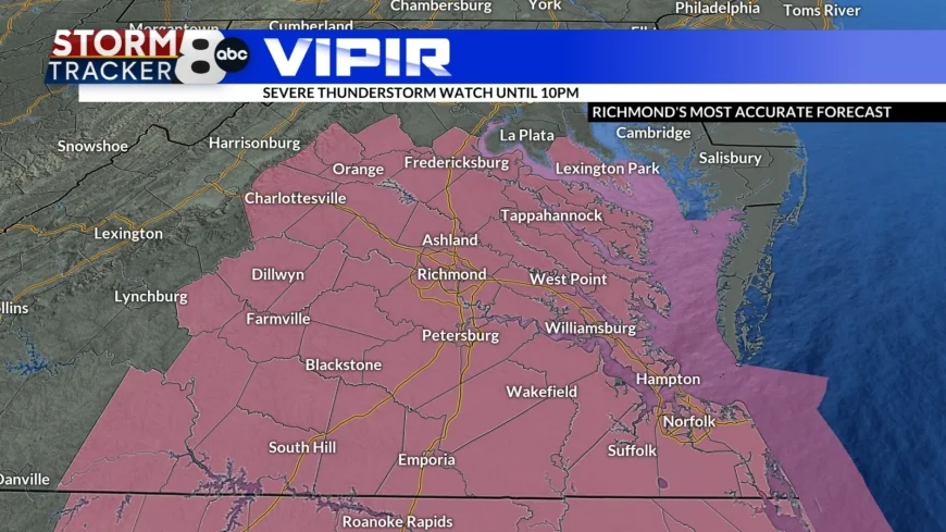

RICHMOND, Va. (WRIC) – A Severe Thunderstorm WATCH is in effect for all of Central Virginia until 10:00 p.m. tonight. The primary risks we are watching out for are damaging wind gusts (60+ MPH), locally heavy downpours, frequent lightning and small hail.
Possible strong to severe storms and possible flash flooding is in the Saturday evening forecast, from west to east, as our latest daily disturbance riding along this frontal boundary slides through the Mid Atlantic Region through tonight.
The showers and storms will be ending altogether tonight between 10:00 p.m. and Midnight tonight.
Overnight tonight into Sunday morning, we will see partly cloudy skies, very muggy temperatures dipping down into the lower to middle 70s and possible patchy fog in locations that see heavy rainfall late on Saturday.
Sunday, we begin a transition in our weather pattern, from weeks of heavy rainfall and strong storms, to finally drier conditions moving forward!
Sunday’s forecast calls for partly cloudy skies, very hot and humid conditions, with highs in the middle 90s and heat index values of 100 to 105 degrees and possible pop-up showers and storms late in the day tomorrow.
As we turn our attention to the new work week, next week, on Monday, we will see a surface cold front fully sweep through the state of Virginia, bringing not as hot and not as humid conditions to the region, great news!
Monday’s forecast calls for partly cloudy skies, very warm and less humid conditions, with highs in the middle to upper 80s and possible pop-up showers and storms late in the day on our Monday.
Tuesday, Wednesday, and Thursday of next work week are all looking delightful under mostly sunny skies, very warm afternoon temperatures, rising well into the 80s to around 90 degrees and tolerable humidity levels.
Finally, next Friday through next weekend, we turn very hot and very humid again as the moisture out of the western Atlantic Ocean returns quickly by then with well above average afternoon temperatures and the return of late day pop-up showers and storms.
TRACKING THE TROPICS: There is a tropical disturbance far out in the open Atlantic Ocean that the National Hurricane Center is monitoring for possible future development, but it has a very low formation chance over the next 7 days.


