StormTracker8: Spring warmth through the middle of next week
 VENN
VENN
Richmond, Va. (WRIC) -- Partly cloudy skies will be with us for this evening and tonight with lows in the upper 50s.

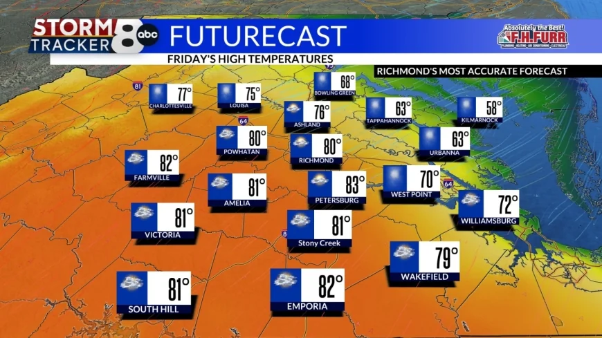
Friday will feature partly sunny skies, and it will be another warm day with highs close to 80 and that'll be for most of central Virginia however our coastal communities along the Northern Neck and Middle Peninsula will be as much as 20 to 25 degrees cooler than the rest of central Virginia.


Saturday will also be a warm day with highs near 80 under partly sunny skies and still our coastal communities will be cooler as they only climb into the lower 70s.


A weak weather system will cross the region later Saturday night bringing us a few showers with lows in the lower 60s.
That system will hang up over Central Virginia on Sunday giving us plenty of clouds and the risk of scattered showers throughout the day. The clouds and scattered showers will keep us cooler for Sunday with highs only 70 to 75.
Partly sunny skies will return for Monday with highs in the middle 70s.
Looking ahead to Tuesday we'll start off partly sunny however we will see some extra clouds increasing late in the day with the chance of a few showers by the evening hours. It will be very mild with highs in the upper 70s.
Wednesday will be a partly sunny day, and it will be breezy and warm with highs near 80.
However, Wednesday night a cold front will cross the region and that'll bring us the risk of rain and thunderstorms into early Thursday.
We should see those storms and showers and early Thursday and some sunshine should return for Thursday afternoon, but it will turn cooler with highs only near 65.
We will go back to normal by next Friday with highs in the middle fifties under mostly sunny skies.


