StormTracker8: VIPIR Alert for Severe Storms Today
 VENN
VENN
Richmond, Va (WRIC) -- A VIPIR alert is in place for today as we run the risk of strong to severe storms making their way into Central Virginia.

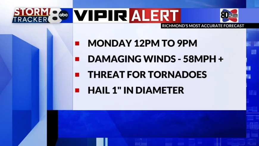
The timing for these storms is from 12:00pm to 9:00pm, moving from west to east.
With the risk of severe weather we could experience damaging winds of 58mph or greater, the chance for tornadic activity, and hail up to 1" in diameter. Watches.


Damaging winds are our greatest threat today as we are in a 60% risk category. This means nearly 60% of storms that form can produce damaging winds of 58mph or greater.
Our next greatest threat will be tornadoes as we are in a 15% risk category, meaning 15% of storms formed could produce tornadoes.
Our smallest risk, which has decreases for south and west of the metro since yesterday, is hail at a 5% risk. From this risk hail of 1" in diameter could develop. Although it is low, we cannot count it out.

Tomorrow, for St. Patrick's Day, we will be experiencing much cooler temperatures in the 40s, but lucky for us the sunshine will have returned!
Similar conditions will be around for Wednesday starting off our morning in the 20s and only warming into the mid 40s by the afternoon under mostly cloudy skies.
Thursday is when we finally see the return of normal March conditions. Highs will be in the upper 50s and partly sunny skies will be overhead.
The Spring season officially begins on Friday at 10:46am and temperatures will be comfortable in the mid 60s under mostly sunny skies. We do have the chance to see a few isolated showers Friday night.
The weekend is looking nice with partly sunny skies and highs in the upper 60s on Saturday and slightly cooling into the low 60s for Sunday. AS we finish off our weekend we could see a few passing showers.
Monday next week will be seasonable in the upper 50s.


