StormTracker8: VIPIR Alert Day for winter storm; Rain & snow with accumulations
 VENN
VENN
Richmond, Va (WRIC) -- We'll start our Sunday off with very wet and cool conditions with temperatures in the low 40s. We could pick up an 1 inch of rain in some locations before we see a transition to snow by early afternoon. Temperatures will be dropping throughout the day.

Between 3pm and 6pm, from northeast to southwest, we will start to see that transition from rain to a mix of rain and snow and then to all snow. As we make that transition the snowflakes will be huge, large half dollar size and then will fill the air. It will look very pretty! That snow will continue for the rest of Sunday night and begin to taper off between 2am and 4am. So, we are looking at a good 8 hours to 10 hours of snow. This will be a wet snow falling on very wet ground, which will initially inhibit snow from accumulating, because the initial couple of hours of snow will have to cool the ground.
Most of the roads will be okay, especially across metro Richmond, however one area of concern for road issues will be in the Middle Peninsula and Northern Neck where roads will become slushy and snow covered by early late Sunday night. This is especially true for where the heavier snow falls.

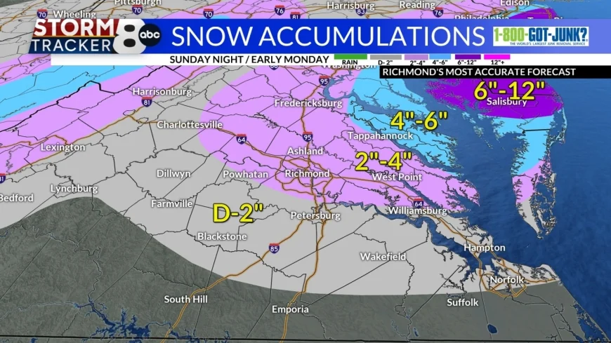
Amelia, Buckingham, Sussex, Prince George, Nottoway, Dinwiddie, and all areas in the grey color will see a dusting to 2". If you are closer to the pink band, you will see the upper end of the range, the farther south & west you are, you will see the lower end of the range.
The City of Richmond, Louisa, Henrico, Hanover, Goochland, Charles City, New Kent, and all areas in the light pink color will receive between 2"-4" of snow. The farther north and east you are the more snow you will receive.
Notice the accumulations for the Northern Neck and some parts in the Delmarva, 4"-6" in the blue, and then more into New Jersey and Long Island, 6"-12" and possibly more.

Monday’s forecast calls for mostly cloudy skies, breezy conditions from time to time and cool temperatures, with highs in the lower 40s.
Tuesday’s forecast calls for mostly cloudy skies, less breezy conditions and cool temperatures, with highs in the lower 40s.
Wednesday will begin a warming trend, back into the 50s, under mostly cloudy skies.
Thursday a weather system will be approaching Central Virginia and sweeping through bringing more beneficial showers to the region, with highs in the 50s.
Finally, next Friday and next weekend, are all looking mild with temperatures in the 50s to near 60 degrees and dry conditions.


