StormTracker8: VIPIR Alert remains in place through Sunday night due to Wet Snow Accumulations
 VENN
VENN
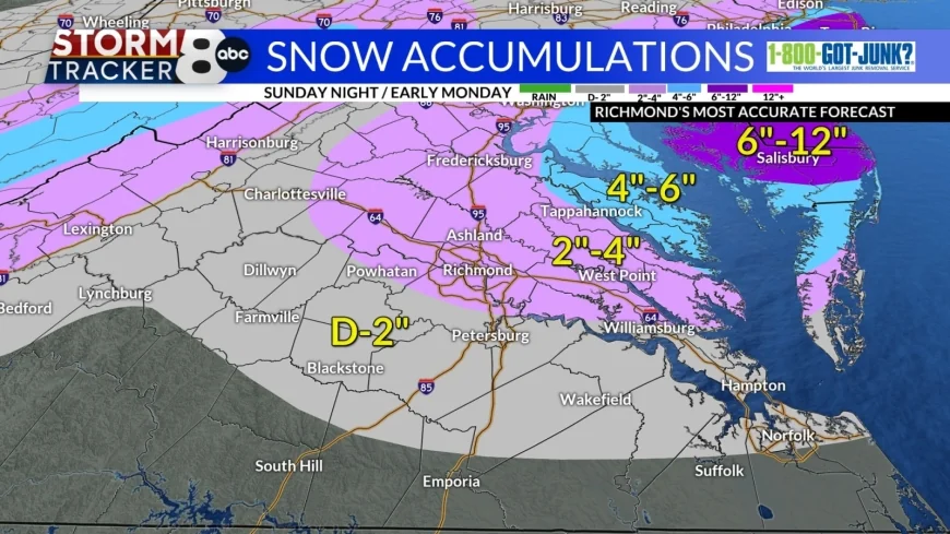
Richmond, Va. (WRIC) -- Our VIPIR Alert remains in place through Sunday night across Central Virginia, due to wet snow accumulations.
Tonight’s forecast on this Sunday night into Monday morning, calls for mostly cloudy skies, breezy conditions from time to time, wet snow through the Midnight hour tonight, then tapering off to snow showers, for especially the Northern Neck, Middle Peninsula, and Eastern Shore of Virginia. The higher snowfall accumulations remain in place for the Northern Neck, Middle Peninsula, and Eastern Shore of Virginia, while we will see lower snowfall accumulations for areas to the south and west of Metro Richmond. Temperatures will drop to around 30 degrees, which will allow for the wet snow to stick to the roads, the roads in the Northern Neck, Middle Peninsula and Eastern Shore will be snow covered more so, then the roads in Metro Richmond and area to the south and west that see less wet snowfall. The roads across Metro Richmond on Monday morning will be wet and slushy.


Monday’s forecast calls for morning snow flurries possible, especially for the Northern Neck, Middle Peninsula, and Eastern Shore of Virginia. Otherwise, we will see some afternoon sunshine tomorrow, highs 40 to 45 degrees and breezy conditions from time to time all day.
Tuesday’s forecast calls for partly sunny skies, and cool temperatures, with highs 40 to 45 degrees.
Wednesday’s forecast calls for mostly cloudy skies, much milder temperatures, with highs 55 to 60 degrees.
Thursday is when we will see our next weather system approach and sweep through Central Virginia, bringing another rainy day to the region, with highs in the middle 50s.
Friday will bring us a possible morning shower, followed by afternoon sunshine and highs in the middle 50s.
The upcoming weekend and early next week, will be mild with partly sunny skies and temperatures in the 50s and in the 60s.


